Hey
This may seem a little to critical knowing how much this aspect of the game contributes to the total gameplay but I was just wondering if the shore could be blured along the egde to give an apperance of depth to the water in BOB 2 somthing of a regional water shading effect so costal waters could be a deep blue brown
the water colour should be looked at simply because Britain is an island and during the battle and in the game air battles tend to take place over beaches making them the most dominating terain in the whole game
This is by no means a critisisim of the historical accuracy of the terain it's just that a grainy looking beach that is too light coloured to be an English beach that abruptly ends to be followed by water of the same generic colour does not look realistic
or more simply put historical realisim has been allowed to trump the realistic look of the terain
however if someone can direct me to the code and textures that make up the beaches and explain thier functions I could facilitate a resonable soloution to this problem
thanks
~Halsfury
The New Big Terrain Thread

Re: The New Big Terrain Thread
Sand texture and accompanying dither are mine but you can certainly modify them to your liking. THey live in Landmap2 and landmaps folder. There is not way to transition from beach to shoreline to water, it is a limitation of the terrain. Also it is that we have to use this one texture to represent the whole of England's and France's coast, it is not ideal but all we have. Feel free to modify to your hearts content.

Re: The New Big Terrain Thread
Halsfury,
I hear you, and also know that the shoreline, and the lack of a shallow water look is BoBII's biggest terrain defect.
None of the BDG men can do anything to improve it presently. The game Engine is sorely limited here.
I hear you, and also know that the shoreline, and the lack of a shallow water look is BoBII's biggest terrain defect.
None of the BDG men can do anything to improve it presently. The game Engine is sorely limited here.

Re: The New Big Terrain Thread
Stickman,
In the course of my recent ObjectAdding, I've been near several BoBII coastlines in the Kent area. Many of them are a hard white line, but along the edge of some coasts, there is a narrow, translucent strip, a bit like a long piece of clear tape between sand and sea. I first saw it on the coast northwest of RAF Manston.
If I get down very close, say worm's eye level, I can see that this strip is continuously looping a faint animation that appears to represent flowing water. Everywhere I've seen it, the animation movement is parallel to the coastline, more like water flowing down a river, rather than towards the coastline, like surf on a beach.
The strip is so thin, and the animation so faint, you can hardly notice it until you're right on top of it. How you'd see it from a cockpit, I have no idea.
Is this some vestige of your old white surf line, or have I gone crazy from ObjectAdding?
Re: The New Big Terrain Thread
scoobared,
You may well know that the BoBII Sea to Land interface does not mate well. The marriage is dysfunctional.
Like a man and wife whom not only do not sleep in the same bed and do not couple together IN & OUT, Ying & Yang, love & kisses,
but do not like to converse with each other, at all in any fashion.
I was the first one to try experimenting with the blendmap file and find what each line did.
Also the only one to try and make a better Sea (texture) - Beach (texture) shore blend, as well as a better Sea (texture) - Docks/Grass (textures) blend.
This was my report:
This was many years ago, but after WoV. I was totally frustrated making a good Sea-Docks/Grass blend.
The game seemed to allow only about 2 pixels of blend interference on that line.
I was much more successful when I tried to "influence" the Sea-Beach shore blend.
Never could completely remove the straight line between the Sea and the Beach, but I did manage to spurt my Sea foam into the Beach, occasionally!
My intent was to make it look like when a sea wave crashes into a rocky shore, white sea foam sprays around.
Even on a gentle sloped sandy beach, when the watery sea runs up the beach as far as it can go as fully liquid,
.. it recedes and leaves a foamy white bunch of sea/air bubbles.
Kisses from Neptune reminding us that this is a water planet, as well, or more than an earth one.
I only have 2 pictures handy of what I did back a few years ago, before blendmap got broken, as to the sea shore.


As you can see, I never could completely eliminate the damned straight shore lines.
But I did break up the straight lines with occasional kisses of (blue or green as your choice may be)
sea invading onto the straight line shore and leaving some white foam.
I was happy with this. Better than we had before. Or now.
Soon after I posted this modification of mine, Scott arranged to have some guy.. to fix the blendmap.
This guy did something to the blendmap, then disappeared !
The only thing he did was to totally KILL the Sea - Beach Shore. I cannot modify that line anymore, I tried to get it back to what I did.. it's gone!
I am still pissed about that.
Maybe you beau coup dinky dao for trying look at terrain too close, for too long time, sailor!
You may well know that the BoBII Sea to Land interface does not mate well. The marriage is dysfunctional.
Like a man and wife whom not only do not sleep in the same bed and do not couple together IN & OUT, Ying & Yang, love & kisses,
but do not like to converse with each other, at all in any fashion.
I was the first one to try experimenting with the blendmap file and find what each line did.
Also the only one to try and make a better Sea (texture) - Beach (texture) shore blend, as well as a better Sea (texture) - Docks/Grass (textures) blend.
This was my report:
This was many years ago, but after WoV. I was totally frustrated making a good Sea-Docks/Grass blend.
The game seemed to allow only about 2 pixels of blend interference on that line.
I was much more successful when I tried to "influence" the Sea-Beach shore blend.
Never could completely remove the straight line between the Sea and the Beach, but I did manage to spurt my Sea foam into the Beach, occasionally!
My intent was to make it look like when a sea wave crashes into a rocky shore, white sea foam sprays around.
Even on a gentle sloped sandy beach, when the watery sea runs up the beach as far as it can go as fully liquid,
.. it recedes and leaves a foamy white bunch of sea/air bubbles.
Kisses from Neptune reminding us that this is a water planet, as well, or more than an earth one.
I only have 2 pictures handy of what I did back a few years ago, before blendmap got broken, as to the sea shore.
As you can see, I never could completely eliminate the damned straight shore lines.
But I did break up the straight lines with occasional kisses of (blue or green as your choice may be)
sea invading onto the straight line shore and leaving some white foam.
I was happy with this. Better than we had before. Or now.
Soon after I posted this modification of mine, Scott arranged to have some guy.. to fix the blendmap.
This guy did something to the blendmap, then disappeared !
The only thing he did was to totally KILL the Sea - Beach Shore. I cannot modify that line anymore, I tried to get it back to what I did.. it's gone!
I am still pissed about that.
Maybe some vestige of white surf foam left.Is this some vestige of your old white surf line, or have I gone crazy from ObjectAdding?
Maybe you beau coup dinky dao for trying look at terrain too close, for too long time, sailor!
Re: The New Big Terrain Thread
stickman wrote:Soon after I posted this modification of mine, Scott arranged to have some guy.. to fix the blendmap.
This guy did something to the blendmap, then disappeared !
The only thing he did was to totally KILL the Sea - Beach Shore. I cannot modify that line anymore, I tried to get it back to what I did.. it's gone!
Murphy's Law of some sort, isn't it!
Well, I guess that animation is a Rowan relic, then. I wonder if the places where the animated strip doesn't show are places of the map that have been revised. It would be cool to somehow tie your white surf blendmap into the animation cycle to get foam lapping at the shores.
Just checked, and your white surf blendmap still exists with water set to LOW, and the animation appears across the entire sea, not just the margins.
Re: The New Big Terrain Thread
Nothing in blendmap was ever animated, including the Sea-Beach line. True that the LOW sea was and is animated.
I never did try and see if one of the unused lower lines is now used for the sea-Beach. I will try.
I never did try and see if one of the unused lower lines is now used for the sea-Beach. I will try.
-
stalkervision

- Chief Master Sergeant
- Posts: 3308
- Joined: 02 Feb 2007, 12:14
Re: The New Big Terrain Thread
This is a fascinating thread I can tell you. 

Re: The New Big Terrain Thread
Time for a peek at what I've been up to for the last 6 months or so:
Still lots and lots left to do...
Still lots and lots left to do...
-
stalkervision
- Chief Master Sergeant
- Posts: 3308
- Joined: 02 Feb 2007, 12:14
Re: The New Big Terrain Thread
PV wrote:Time for a peek at what I've been up to for the last 6 months or so:
Still lots and lots left to do...
wow PV that is just amazing
Re: The New Big Terrain Thread
Very nice 
Theoretically I should have a book about dunkirk, but I am not at home.
Theoretically I should have a book about dunkirk, but I am not at home.
Re: The New Big Terrain Thread
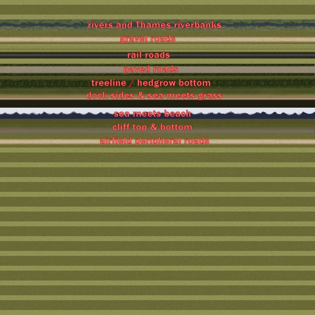
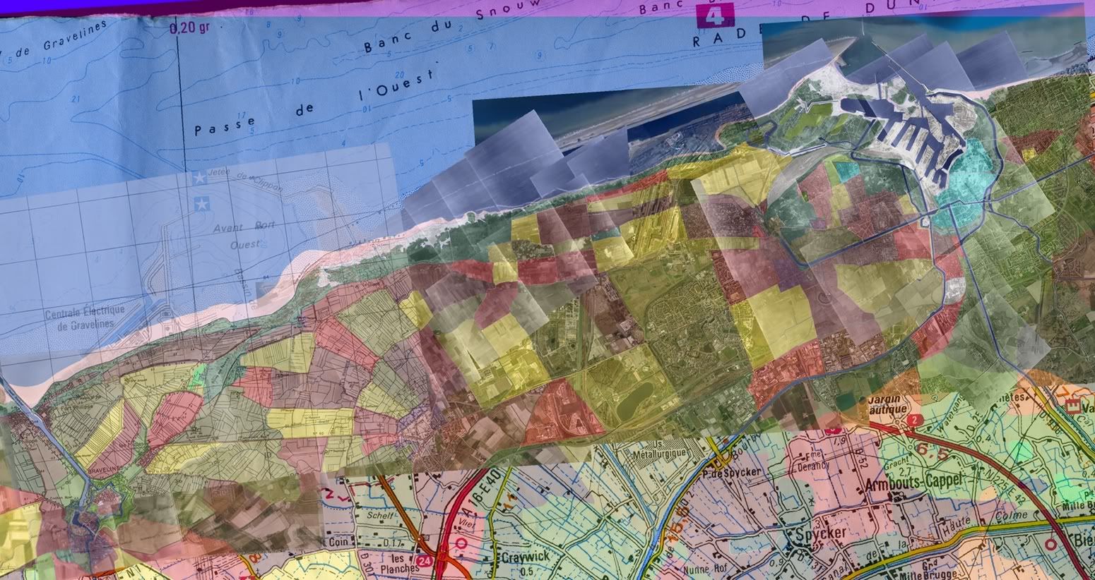
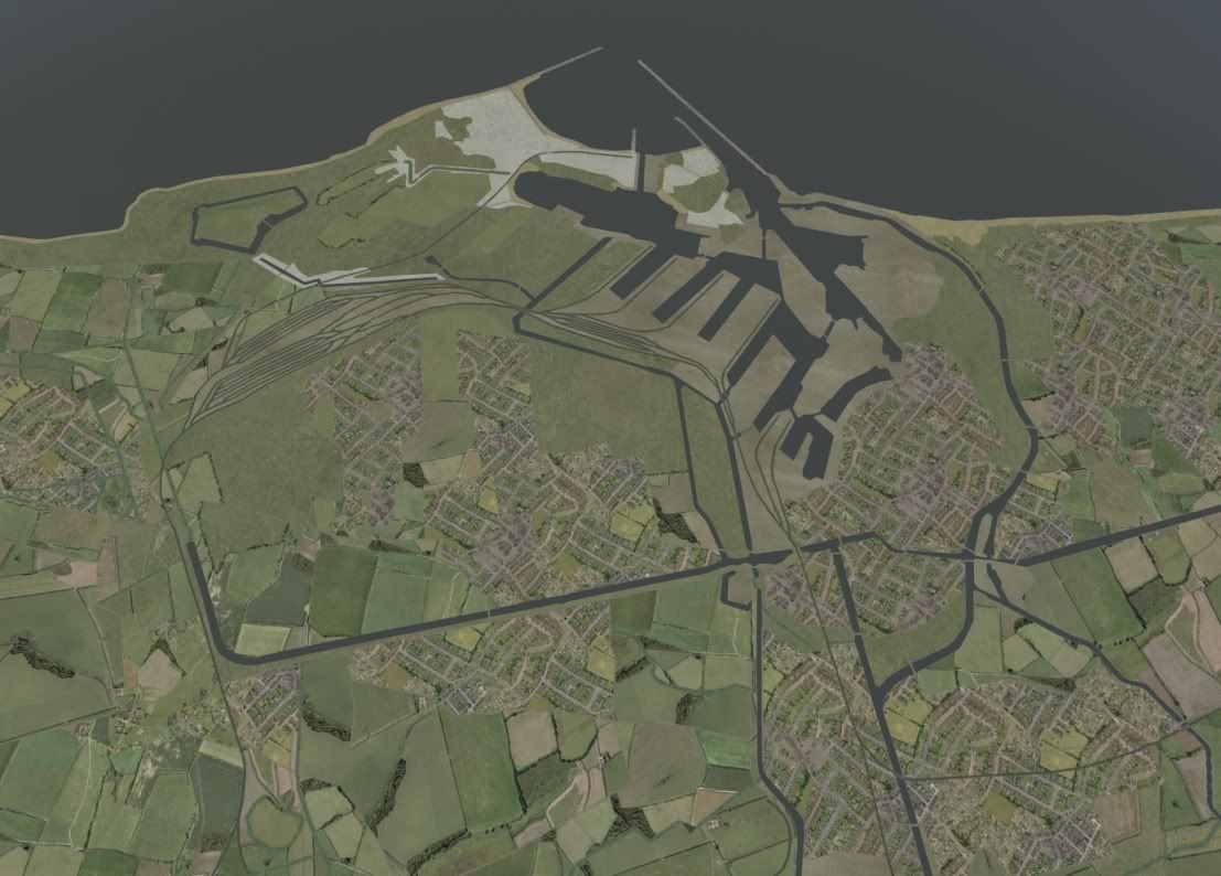
A look at the detail of constructing the terrain: having built the stack of images,
I map out the landuse tiles by hand drawing the outlines, tracing over the map
or photo I use as reference - often switching out among several in the stack,
to get the best information - sometimes nothing is from the right period, and
I just have to guess. Near Dunkerque, the data is excellent. The TARA recon
images from 1944 overlap, and provide ample detail. Here is a chunk of the
harbour:
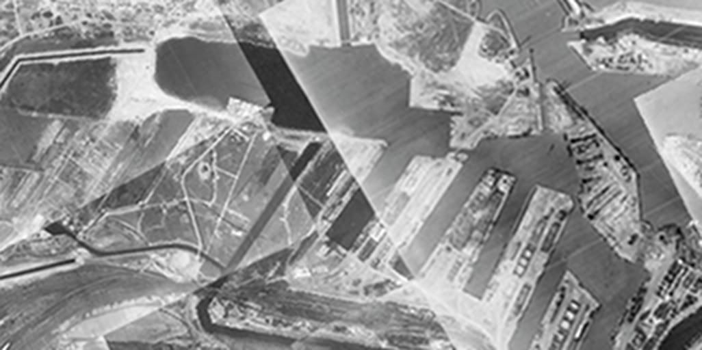
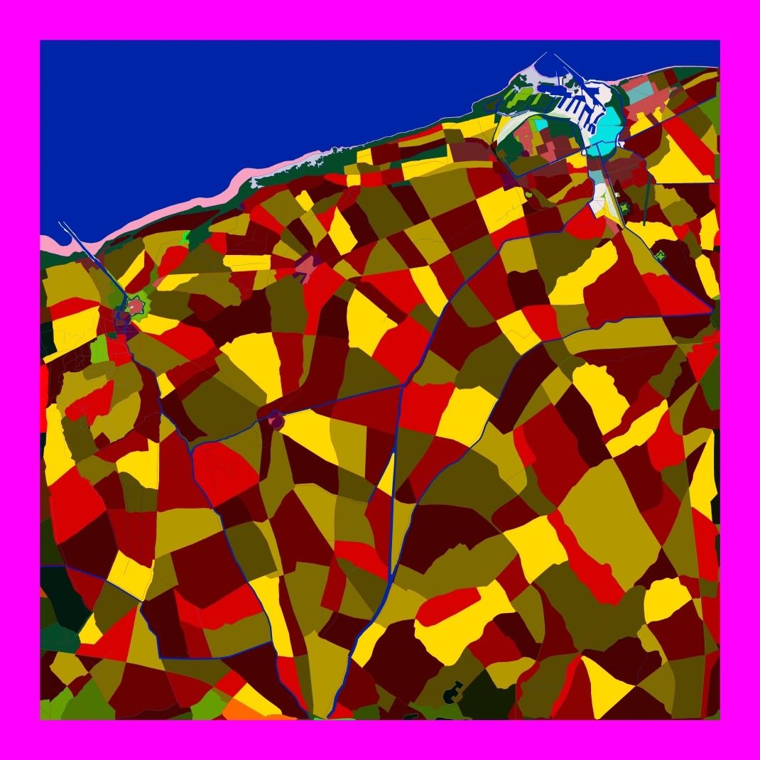
and here are two tiles covering that area, detailed as well as seemed reasonable
to get away with:
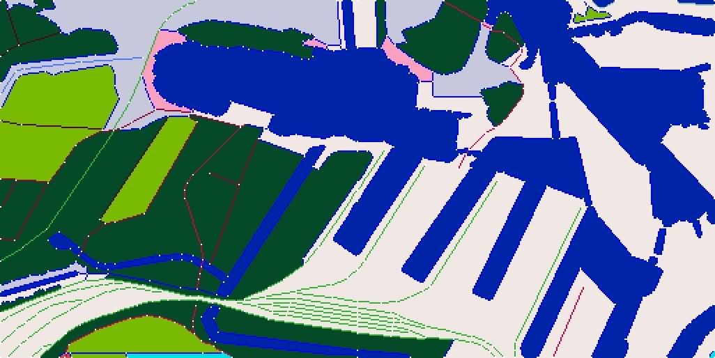
But no, it turns out I used far more than my limit of 256 white dots (the landuse
is carved up by borders constructed of straight lines going from dot to dot, and
only 256 are permitted per tile. The tiles are compressed and encoded by just
storing the positions of the dots, and the direction of the lines between them.)
So, I have to strip out around 100 dots between these two tiles - I think it
was 65 on the left and 30 on the right - in order to get them to compile. I have to
try to remove the dots while losing a minimum of landscape information, to keep
the terrain as accurate and detailed as possible. The final result looks like this:

Both tiles have the maximum allowable dots, but still show far less detail than is evident
in the photos. Compromise is constantly required.
The landuse is now pretty much successfully generated, now it remains to tune up the
heightmap - fortunately this area is all at about 4m above sea level, but harbours are
always a problem. If you draw a dock, and set it at its true height, somewhere around
4m, it will be rendered hovering in the air, with no sides. The height is anchored at the
white dots, and the terrain mesh is built of triangle facets with the dots as vertices.
To have the dock sit at its true height, and also have a side going down to the water,
I'd have to draw two lines around the edge, one whose dots are set for the pier height,
and the other beside it set for the water height. But this would double the number of dots
required, which are already maxed, and the sides would not even be vertical. The rendering
engine does not like lines too close together -it would insist on two spaces between the lines.
But each space is about 5m horizontal distance, so the 4m height would be changed over
a 10m space, yielding a very shallow slope. So, it is impossible to do a good job with the
terrain engine. The solution is to make dock/pier objects, set the terrain to zero height at the
water's edge, and where possible set the terrain height to the correct value as close to the
pier as possible, hoping that the pier object doesn't have to be too huge to cover the space
from the water to the point where the terrain height can take over.
This area is also full of canals, whose edges present similar problems to the sides of the piers.
in some cases a line can be run along the side of the canal, if the shapes aren't too complex
(so the dot count stays legal), and these can often be roads, which are usually there anyway.
But there are just lots of places where it is impossible to find a perfect solution, so one has to
be resigned to the fact that it is only going to look good from a distance; and fortunately things
look best with lots of vertical distance, which is usually how they are viewed. Only I will zoom in
and see all the flaws...
I map out the landuse tiles by hand drawing the outlines, tracing over the map
or photo I use as reference - often switching out among several in the stack,
to get the best information - sometimes nothing is from the right period, and
I just have to guess. Near Dunkerque, the data is excellent. The TARA recon
images from 1944 overlap, and provide ample detail. Here is a chunk of the
harbour:
and here are two tiles covering that area, detailed as well as seemed reasonable
to get away with:
But no, it turns out I used far more than my limit of 256 white dots (the landuse
is carved up by borders constructed of straight lines going from dot to dot, and
only 256 are permitted per tile. The tiles are compressed and encoded by just
storing the positions of the dots, and the direction of the lines between them.)
So, I have to strip out around 100 dots between these two tiles - I think it
was 65 on the left and 30 on the right - in order to get them to compile. I have to
try to remove the dots while losing a minimum of landscape information, to keep
the terrain as accurate and detailed as possible. The final result looks like this:
Both tiles have the maximum allowable dots, but still show far less detail than is evident
in the photos. Compromise is constantly required.
The landuse is now pretty much successfully generated, now it remains to tune up the
heightmap - fortunately this area is all at about 4m above sea level, but harbours are
always a problem. If you draw a dock, and set it at its true height, somewhere around
4m, it will be rendered hovering in the air, with no sides. The height is anchored at the
white dots, and the terrain mesh is built of triangle facets with the dots as vertices.
To have the dock sit at its true height, and also have a side going down to the water,
I'd have to draw two lines around the edge, one whose dots are set for the pier height,
and the other beside it set for the water height. But this would double the number of dots
required, which are already maxed, and the sides would not even be vertical. The rendering
engine does not like lines too close together -it would insist on two spaces between the lines.
But each space is about 5m horizontal distance, so the 4m height would be changed over
a 10m space, yielding a very shallow slope. So, it is impossible to do a good job with the
terrain engine. The solution is to make dock/pier objects, set the terrain to zero height at the
water's edge, and where possible set the terrain height to the correct value as close to the
pier as possible, hoping that the pier object doesn't have to be too huge to cover the space
from the water to the point where the terrain height can take over.
This area is also full of canals, whose edges present similar problems to the sides of the piers.
in some cases a line can be run along the side of the canal, if the shapes aren't too complex
(so the dot count stays legal), and these can often be roads, which are usually there anyway.
But there are just lots of places where it is impossible to find a perfect solution, so one has to
be resigned to the fact that it is only going to look good from a distance; and fortunately things
look best with lots of vertical distance, which is usually how they are viewed. Only I will zoom in
and see all the flaws...
Re: The New Big Terrain Thread
OK, things are progressing very well with the Dunkerque project. As usual,
there's nothing much to see until the very end of the project, so here is an
image which is going to be pretty much the final appearance, except for
a few little edits reflecting new data from more newly posted TARA images
indicating more accurate mapping for 1940 vs 1944 (the latter being most
of the TARA material):
Note this is just the upper right hand corner of the new mapped region. Here
is an indication of the whole region:
Oh, by the way, when IL2CoD was in pre-release promo mode, I saw some map images
posted that showed a rather different profile of the shoreline between Gravelines and
Dunkerque, including deep water harbours which were built in the '60s and '70s. Anyone
who has the game, did the release version retain these errors?
Oh, and one more thing. Scavenging information from half a world away, I can make mistakes;
I rather suspect that the change in the quantity of sand below the high tide line (I usually try
to aim for a mid-tide) along the length of the shoreline may be a function of the time of day when
the images I was using were taken. There is no modern information on this, as the whole
stretch is now reshaped for industrial dockyards.

Re: The New Big Terrain Thread
Very well done PV.
Looks great.
Looks great.
Re: The New Big Terrain Thread
Answering my own question, I picked up a copy of IL2-CoD mostly to see how they've donePV wrote:
Oh, by the way, when IL2CoD was in pre-release promo mode, I saw some map images
posted that showed a rather different profile of the shoreline between Gravelines and
Dunkerque, including deep water harbours which were built in the '60s and '70s. Anyone
who has the game, did the release version retain these errors?
their landscape, and I found this, in the mission editor:
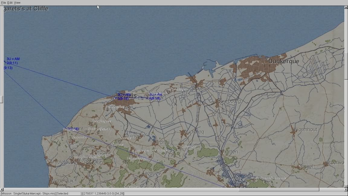
Zooming in:
A very careful and skillful rendering of a massive harbour dredging project conducted in the 1960s and 70s.
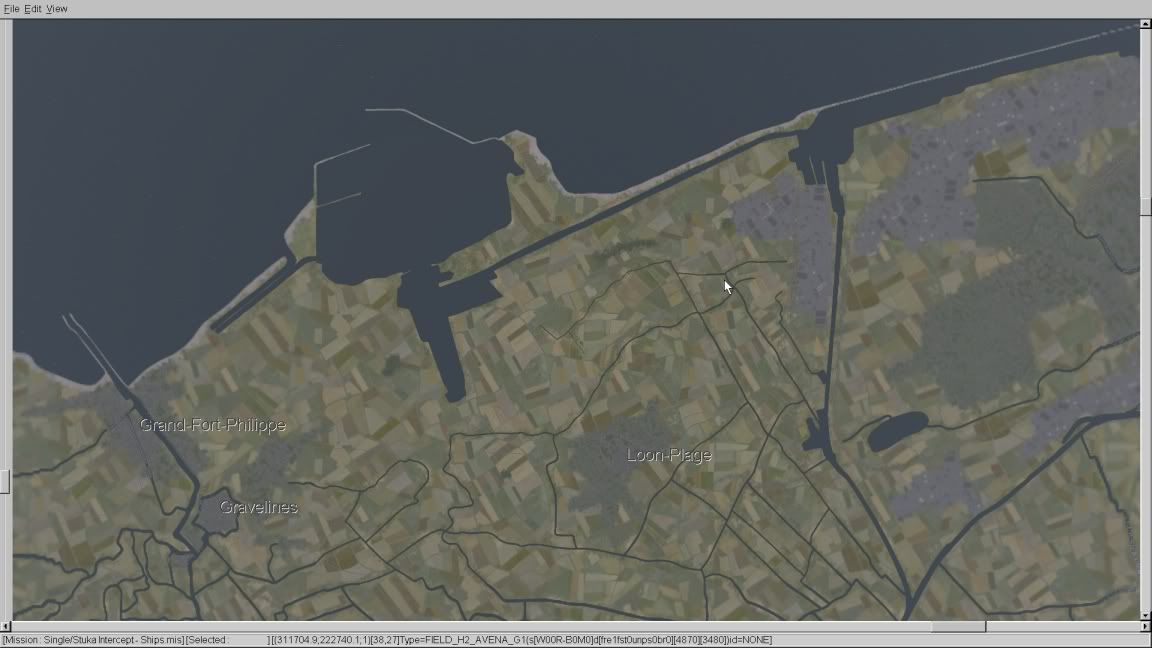
*Sigh*. I rather find it heartbreaking, the effort that went in to doing the wrong era. Looking at Gravelines,
zooming in further, I find this:
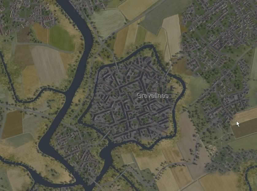
not nearly as brilliant as the exquisite work I saw in a screenie which I believe is from RoF, and the town
square is conspicuously absent from the centre, but still not too bad a job. I presume they got it right
because it still exists on Google Map satellite images.
I have to concur with the reviewer at SimHQ, Fearless Frog, who wrote "It's infuriating to think of flight-sim
Michelangelo deciding to join forces with Homer Simpson to produce this odd and curious master-class of
inconsistency."
Who is online
Users browsing this forum: Yahoo [Bot] and 27 guests