Hi,
Today, I planned a short hop between Yakima WA to Olympia WA with the following flight plan KYKM YKM (V204) OLM KOLM roughly 111 nautical miles leg at
8500 feet. There were some strong south west winds around 45-50 kts, which made my ground speed barely 55-60 kts. The report was for some precipitation at the second half of the trip and icing conditions (it was -7C at 8500 ft) I know it is a suicide to embark on a flight like that in real world in a Cessna 172 trough mountainous terrain with clouds and icing reports with visual flying rules, but that's what the sim is for.
I started my flight, little challenging during takeoff at Yakima but was OK. It's been a long time since I've tested myself in strong winds. As the flight progressed and I was tracking 50nm from YKM to redirect to OLM, I was several times in and out of IMC (I was flying visually btw ) and was wondering whether the sim will surprise me with icing. Beside the clouds I was in raining conditions at some point and was thinking, that ice should form either on the prop or at the flight surfaces. After while, the plane got out of the rain and the clouds became more scares, as I was checking whether I was on track with OLM VOR the autopilot started to veer the plane to the right. I thought, I messed with the nav mode and disengaged and took control. The plane felt right wing heavy, I had to apply corrections. Excited and surprised I thought I got the long anticipated icing and I was loosing aerodynamics. I spotted 2W3 near Eatonville and headed at that direction. I had the luck, this small airstrip was totally VFR. At final I decided to apply some flaps for more steady approach. I almost crashed, with the first notch of flaps the plane wanted to steer heavily to the left, realizing that ice was not the culprit there I quickly corrected my mistake. I managed the land at 90kts without flaps and exited the runway with several feet.
Being safely on the ground, I realized that I have neglected the mechanic warnings about my left flap for some time. Here are some shots from the trip...
First signs of bad weather during the flight...
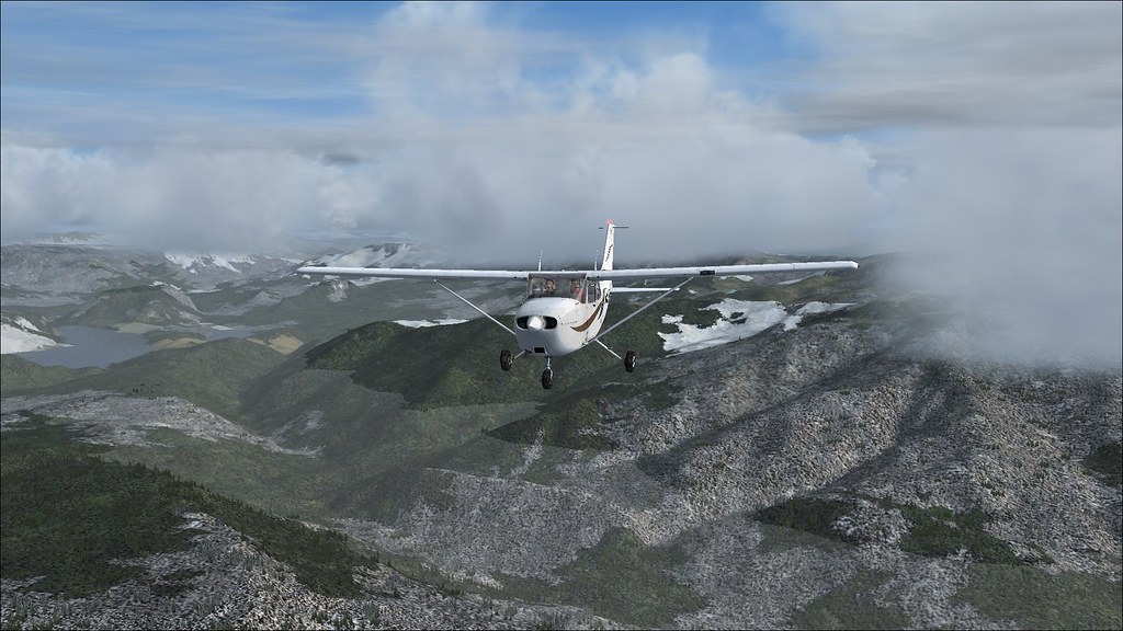
looking a bit scary...
Safely on the ground the problem is clearly seen...
This was one of the rear emergencies I used to have in the A2A planes, and I decided to share with the community. The immersion and the realism are amazing. I hope, I didn't bore you to death with my writing.
Cheerz,
Will
Emergency in 172
Emergency in 172
Bonanza, Skylane, Skyhawk, Cherokee, Cub, Texan, Mustang, Warhawk, Spitfire, Flying Fortress
Re: Emergency in 172
Good save. Guess you missed this :
WSUS06 KKCI 132027
SFOU WS 132027
SIGMET UNIFORM 1 VALID UNTIL 140027
SIGMET
WA OR AND CSTL WTRS
FROM 30E HUH TO 50SE YDC TO 60WSW PDT TO 20N ONP TO TOU TO 30E
HUH
OCNL SEV TURB BTN 050 AND FL200. DUE TO STG LOW LVL WNDS AND MTN
WV ACT AND STG UDDFS AND LLWS. CONDS CONTG BYD 0027Z.
WSUS06 KKCI 132027
SFOU WS 132027
SIGMET UNIFORM 1 VALID UNTIL 140027
SIGMET
WA OR AND CSTL WTRS
FROM 30E HUH TO 50SE YDC TO 60WSW PDT TO 20N ONP TO TOU TO 30E
HUH
OCNL SEV TURB BTN 050 AND FL200. DUE TO STG LOW LVL WNDS AND MTN
WV ACT AND STG UDDFS AND LLWS. CONDS CONTG BYD 0027Z.
Re: Emergency in 172
Nope! Yikes a SIGMET, man I was nuts making that flight. Thanks for the heads up. I knew it's a bad idea to get weather from skyvector only.BrianW wrote:Good save. Guess you missed this :
WSUS06 KKCI 132027
SFOU WS 132027
SIGMET UNIFORM 1 VALID UNTIL 140027
SIGMET
WA OR AND CSTL WTRS
FROM 30E HUH TO 50SE YDC TO 60WSW PDT TO 20N ONP TO TOU TO 30E
HUH
OCNL SEV TURB BTN 050 AND FL200. DUE TO STG LOW LVL WNDS AND MTN
WV ACT AND STG UDDFS AND LLWS. CONDS CONTG BYD 0027Z.
GFA Tool in Aviationweather site is very useful for areal forecasts.
Cheerz,
Will
Bonanza, Skylane, Skyhawk, Cherokee, Cub, Texan, Mustang, Warhawk, Spitfire, Flying Fortress
Re: Emergency in 172
You can get this from Skyvector too. It's under the "layers" option (next to the Lat/Long on the top right), with a bunch of other nice tools if you haven't seen them yet.
Re: Emergency in 172
Thanks BrianW! I know them, but I hadn't checked the "Sigmet" and "Outlook" marks, in order to see the bigger picture. I guess, check and double check the weather in the future - lesson learned.BrianW wrote:You can get this from Skyvector too. It's under the "layers" option (next to the Lat/Long on the top right), with a bunch of other nice tools if you haven't seen them yet.
Cheerz,
Will
Bonanza, Skylane, Skyhawk, Cherokee, Cub, Texan, Mustang, Warhawk, Spitfire, Flying Fortress
Who is online
Users browsing this forum: No registered users and 28 guests