All of Kent County revealed circa 1940s in Google Earth

Battle of Britain "Wings of Victory"
new reply
User avatar
stickman
BDG
Posts: 8754
Joined: 05 Nov 2004, 13:17
Location: Oahu, Hawai'i

All of Kent County revealed circa 1940s in Google Earth

Post by stickman »

This was not around some months ago, and I just noticed it, researching the Shorts Brothers Factory, and the Pobjoy Engine Works.

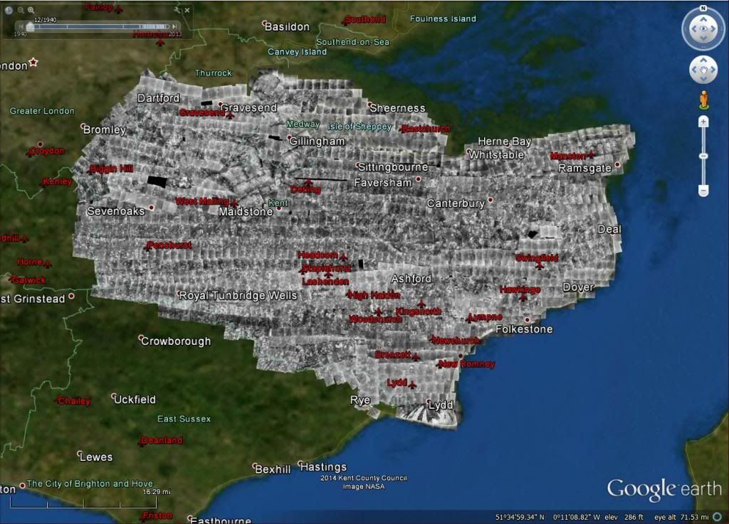
My understanding is that the Kent County Council provided these historical aerial photographic images to Google.
And I hope that Kent County made a good profit doing so! :)
Google can afford to pay good for this, to stay competitive. Google has my attention, once again, for such things.

Image

Oh! yeah! I gotta look around here.

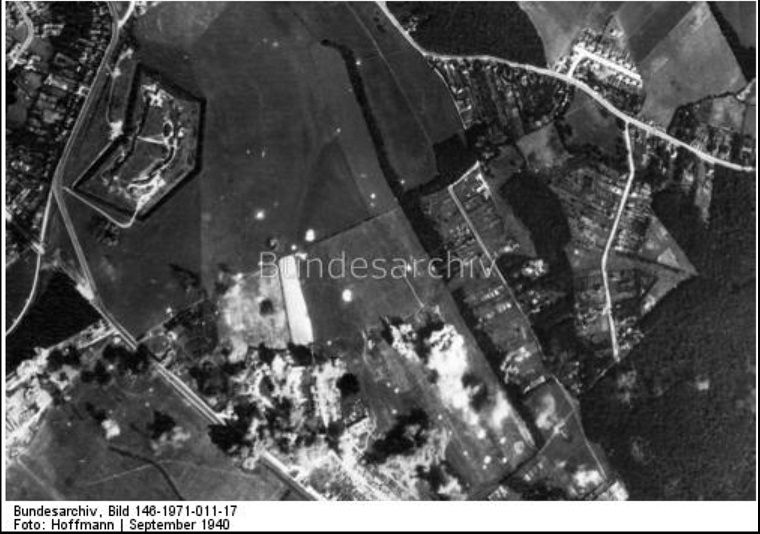
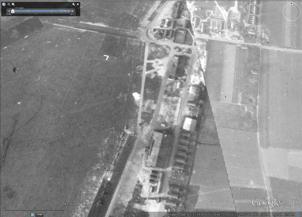
Looking at West Malling airfield, the hangars and the buildings behind them. Ben made it look just like this when he remade the airfields for v2.12.
These aerials are assembled as a "patch work quilt" but they all fit together pretty well.
Google date stamps this all.. as December 31, 1939, but what the hell do they know!? Some are 1939 or 1940 and more are other years to 1945, as I see and know.

Image

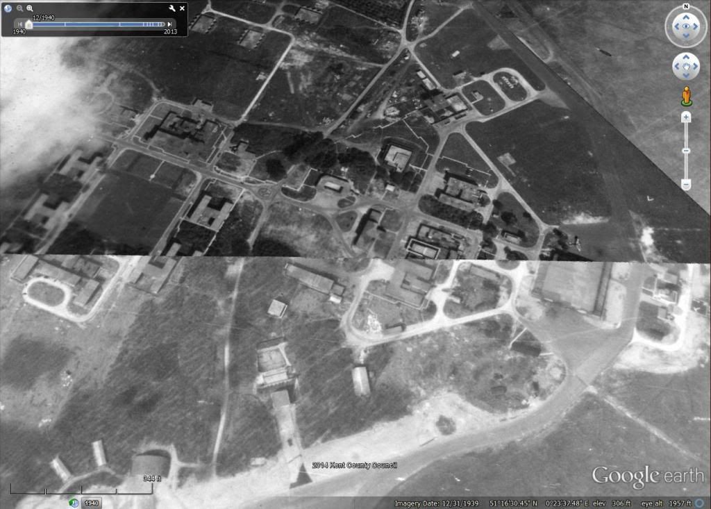
I built Manston airfield for v2.12 from a righteous & big res 1939 aerial photo, and had to took a look at it, here in Google, to confirm that I made it OK.
The east side of the airfield, and buildings there. I see one hangar and and another aircraft shed bombed out, as well some other buildings behind them.

Image

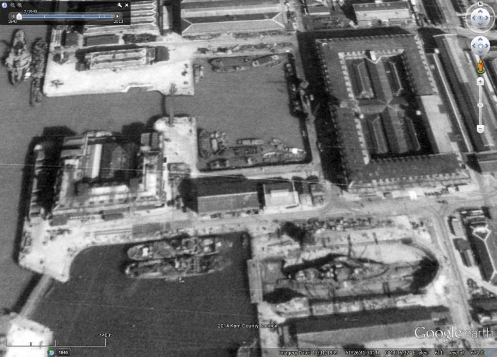
When I made Sheerness Naval Base last year, these Kent County aerials were not available, and in close up zoom looks.
I could have done a bit better placing building types if I had, rather than just working from some good hi res maps.

Hah! Rats Bay! Fitting for a naval base dock-side place. I love some English place names. :)
Image

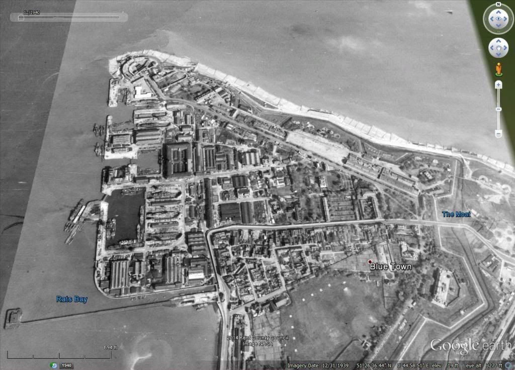
Had to zoom in real close and see the ships, boats, lighters and barges, as well some buildings around the dry docks.
I could stuff some more boats, etc. in what i previously made. Base looks real busy.

Image

Of course, if ya'all know me, then you'll know I am not just an ex-sailor, but also one of them crazy American "gun nuts"!
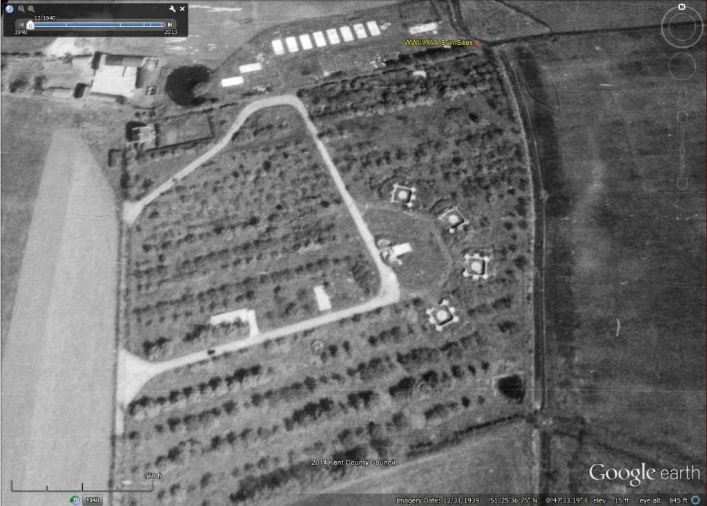
So I had to look around and see some Anti Aircraft Command Heavy AA Troop (four 3.7" guns) layouts.
Not all are shown here in Google, but many are that I ain't never seen before. I am interested in how they were laid out, and what direction they were "pointing".
Most were pointing to south east, as expected, but some were pointing south or east, depending on location and expected threat approach.
This Troop is a Thames & Medway South Troop, called TS1 Scrapsgate (there is another lovely English place name!) that is southeast of Sheerness Naval Base.
Pointing east by north-east to the North Sea. I have this one placed in v2.12, and firing.
Also an unusual HAA site, of which most were placed in open farm fields, this one was hidden in a farmer's apple orchard.
"You boys eat all the apples you want, just don't let the Huns get here and eat 'em!"

Image

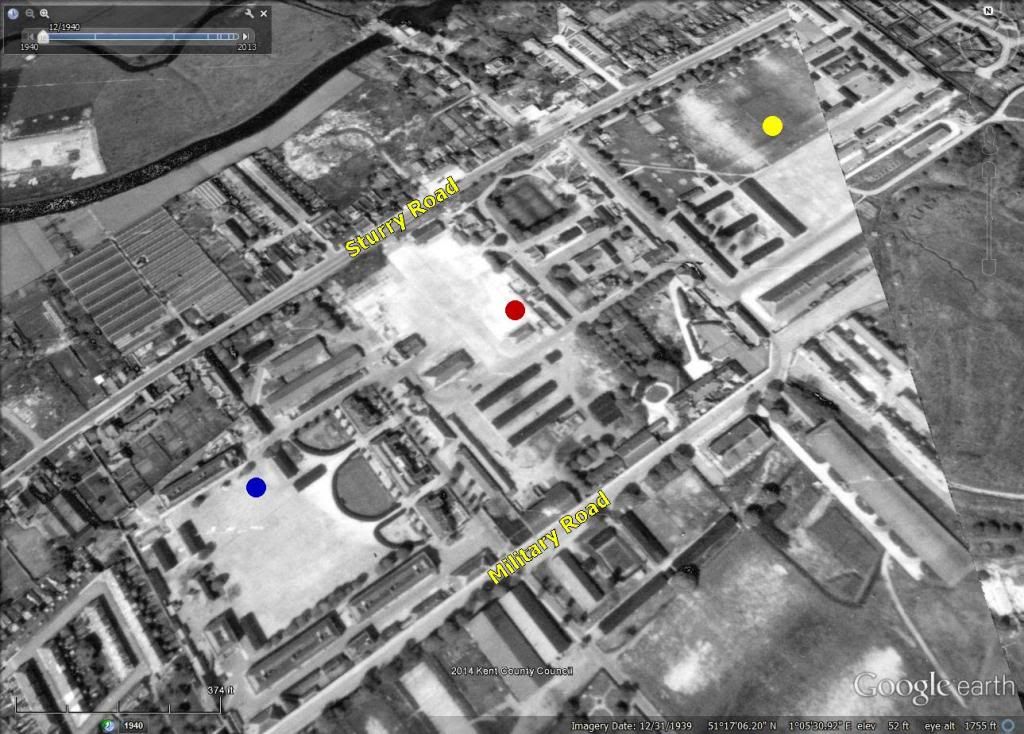
Speaking of ground troops, I see "factories" in BoBII that are called as use of "Industry".
These are Canterbury, Maidstone, and Faversham.
I often wondered what type of manufacturing Industry was in those places, and found no factories that produced things.
Then I saw that "Industry" means producing Royal Army riflemen and machine-gunners! OK Royal Army Regimental Depots.
I've had my eyes on these Targets for a year, now.
Canterbury is one Target that I want to reproduce, and after a lot of research, I know where it is, what it did, and what it looked liked.

Blue dot is the Infantry Barracks, red dot is the Artillery Barracks, and the yellow dot is the "old" Cavalry Barracks.
Image

OK, back to real factories, which is my current concern and priority to reproduce.
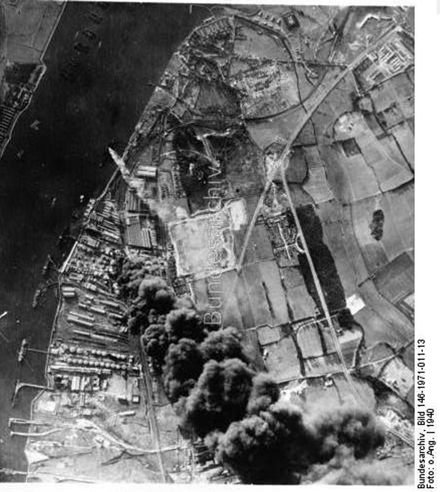
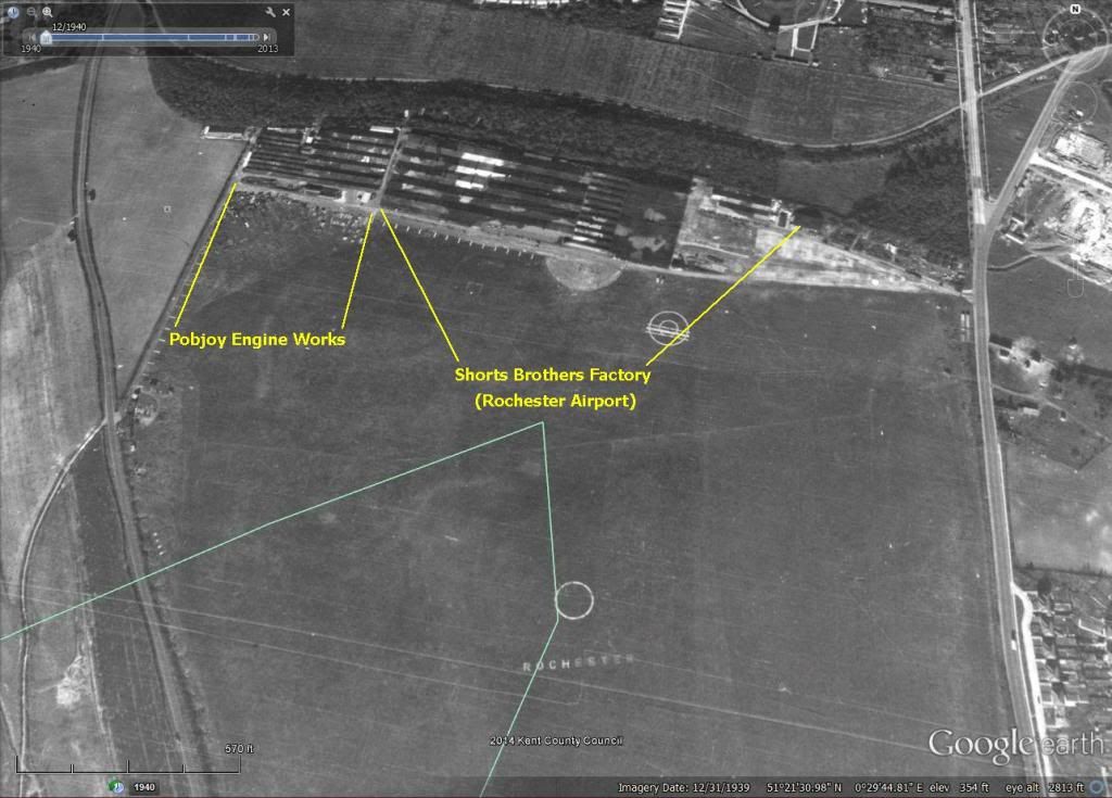
Right now I am looking at the Shorts Brothers Factory and the Pobjoy Engine Works.

I know where the Shorts Brothers were producing sea planes on the Medway River at Rochester, before WWII. In 1940 producing Stirling bombers.
I've a lot of detailed maps and plans of this riverside factory.
Seems that this place was interlaced underground with all kinds of tunnels that had work shops and other facilities down there.
The Kent History Forum, which has a wealth of information there, showed me. Those Kent History Forum folks are serious history buffs about their County!

Image

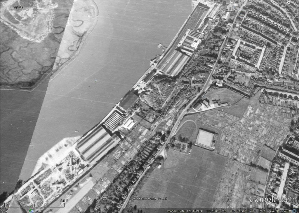
Then, in 1934, Shorts Brothers purchased some land just south of Rochester at the Rochester Airport.
Also bought the Pobjoy Engine Works that was there before Shorts built a new factory right butt-up next to it.
So.. here is another aircraft factory with an airfield right with it. I'm no longer surprised.

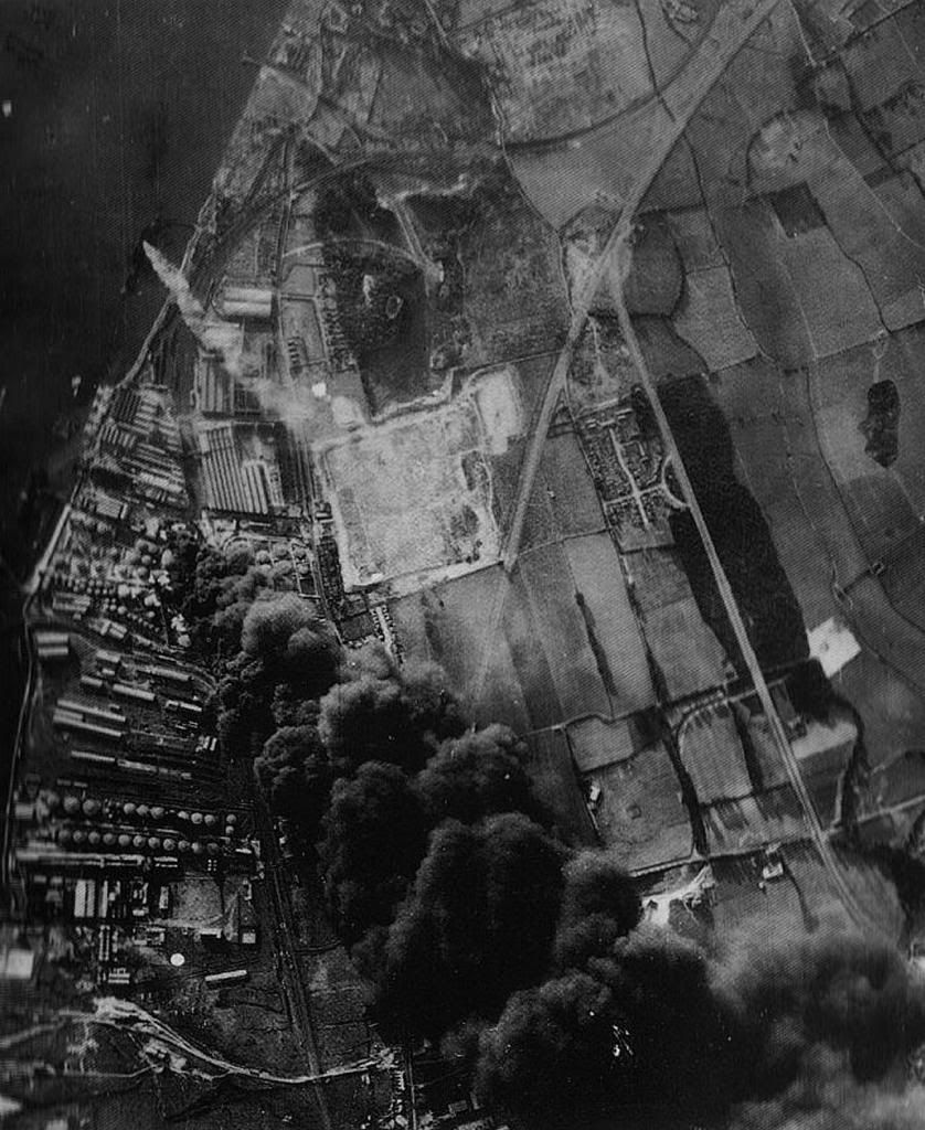
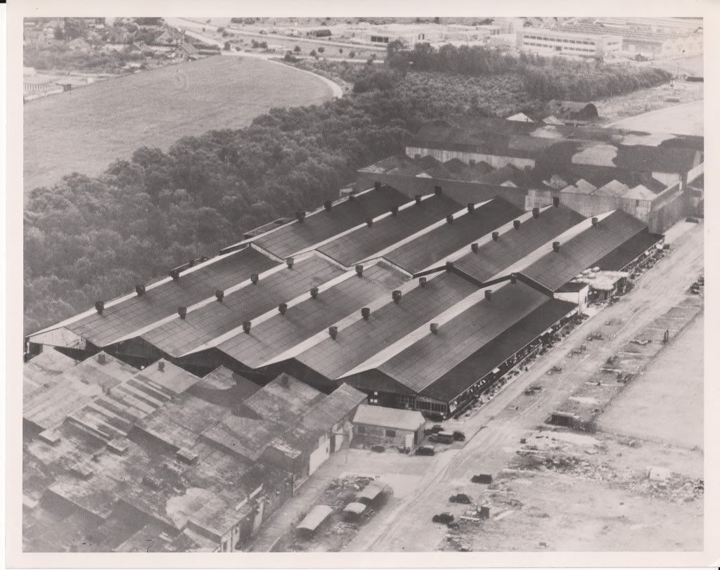
Shorts Brothers & Pobjoy Engine Works at Rochester (airport). Notice the camouflage on factory buildings and the two hangars.

Image

The same Shorts brothers factory with the older Pobjoy Engine Works in the left corner of pic. Hangars and old Pobjoy buildings are camouflaged here.
Picture and explanation from the Kent History Forum, once again. Those guys know their County history! :)

Image

I am now working on reproducing these 2 (or is it 3?) factories to resemble what they actually looked like.

User avatar
PV
BDG
Posts: 5188
Joined: 13 Nov 2004, 08:21
Location: Lost in the tundra, Canada

Re: All of Kent County revealed circa 1940s in Google Earth

Post by PV »

Wow. That's more material than I could ever use.
Years' worth. Great stuff.

two27
Master Sergeant
Posts: 1061
Joined: 17 Apr 2011, 20:02

Re: All of Kent County revealed circa 1940s in Google Earth

Post by two27 »

Shorts Brothers, Medway River pic. Is that final assembly of 4-engine sea planes in lower left corner with wide ramp into river?Assemble, roll to water, and fly off.

Maybe a Sunderland. https://en.wikipedia.org/wiki/Short_Sunderland

User avatar
stickman
BDG
Posts: 8754
Joined: 05 Nov 2004, 13:17
Location: Oahu, Hawai'i

Re: All of Kent County revealed circa 1940s in Google Earth

Post by stickman »

Is that final assembly of 4-engine sea planes in lower left corner with wide ramp into river?Assemble, roll to water, and fly off.
Yeah.
Might be Sunderland sea planes.
In 1937 S.27 Sunderland production was started there.
In 1939 S.26 G Class sea planes.
In 1940 S.33 Empire Flying Boat.
In August 1940 S.29 Stirling bombers. These I believe, had their final assembly done at the newer factory at Rochester Airport.

User avatar
ShadowShooter
Senior Airman
Posts: 141
Joined: 10 Mar 2011, 11:50
Location: Queensland, Australia

Re: All of Kent County revealed circa 1940s in Google Earth

Post by ShadowShooter »

Very nice find, stickman. Beautiful detail! :)

User avatar
ShadowShooter
Senior Airman
Posts: 141
Joined: 10 Mar 2011, 11:50
Location: Queensland, Australia

Re: All of Kent County revealed circa 1940s in Google Earth

Post by ShadowShooter »

The mention of Rochester stirred my memory a bit, and reminded me of some Luftwaffe aerial photos I'd seen on the Bundesarchiv site. Here, according to the description, is one of Rochester airport during a raid in september 1940:
Image

This is just the small preview shot. The full original is 3832x2722 pixels. The catch is you have to pay to access it. Or as the webpage literally puts it: "For free: Nein". :D I don't know how much it costs, but in case you're interested stickman here is the page:
http://www.bild.bundesarchiv.de/cross-s ... 55/?search

If you do a search there for "England 1939-1940" you'll find among the pages a number of other similar shots, including one of a raid on an unidentified oil refinery.
Image

Hope this is useful.

User avatar
stickman
BDG
Posts: 8754
Joined: 05 Nov 2004, 13:17
Location: Oahu, Hawai'i

Re: All of Kent County revealed circa 1940s in Google Earth

Post by stickman »

Shadow Shooter,

Ah, thanks for the link to Das Bundesarchive. It will be useful.

Yesterday I already built the Pobjoy Engine Works (Spit Parts in game)
and the Shorts Brothers Factory, which was the final (wings to fuselage) assembly point for Stirling bombers at the Rochester Airport factory(s).

Later this week I am going to rebuild the older Shorts Brothers seaplane factory (building Stirling bomber fuselages and wings in August 1940, rather than seaplanes)
to be trucked down south a piece to the Rochester Airport, where newly assembled wheeled bombers can take off from.

Both of these factories I am moving slightly to better BoBII realistic locations.
I'll need my Canadian cousin, Pete to remake some better underlying terrain for this Rochester place. Which he always volunteers to do, bless him!

That unknown oil refinery bombed in August 1940 is unfamiliar to me. It's not Purfleet Oil Refinery on the Thames, which I researched last year,
and I am familiar with, and is on my To Do List to remake better historically, after I redo the factories.

From Das Bundesarchive. (I expanded their given pic slightly here with Paint Shop Pro, beg forgiveness!)
This photo shows the piers sticking out to the Thames better than i saw the same photo from another site.

Image

Same LW photo that is widely circulated around the web. Some better detail.

Image

I see from OldMaps.uk maps where the crude oil, and the final distilled product storage tanks are.
That "tank farm" is where the German bombs hit in this photo, Towering Black Smoke!

I see two separated parallel rows of many small circular objects closer to the river. This I believe to be rows of Distillation Columns,
which do the "boiling" of the crude oil into different products like bunker fuel for ships, diesel, naptha, and gasoline.
Build the columns tall enough and you can make propane and butane, too.

Climbing up to the top of a Debutanizer Column is scary, I'll tell you.
The climb up the vertical ladders has yours arms worn out, huffing and puffing lungs, (even when I was a young 40 years old)
and at the top of the tower, it is swinging around in a circle a yard's length around from center point, from the wind!
I'm never afraid to look down, though. That's where I wanna be!
This is just the small preview shot. The full original is 3832x2722 pixels. The catch is you have to pay to access it. Or as the webpage literally puts it: "For free: Nein".
For free Nein!

Well, few good things are for free.
This poor working slob can barely pay for the outrageously priced house mortgage!
I'm working on a good Battle of Britain historical simulation for free tho. Maybe I'm a damned fool?
I got ways of getting around free sample photos and blowing them up, to get what I want and need.
Pete told me not to post such Hi Res, Hijacked photos from sellers of such items, on the public forum.
OK. I won't do so.

new reply

Return to “BOB2 General Discussion”

Who is online

Users browsing this forum: No registered users and 9 guests